2020
04/09/2020
|
Avalanche Summary
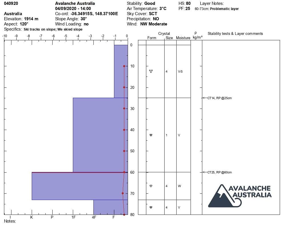
No recent avalanche activity Snowpack Summary Height of snowpack 80cm The top 60 cm of the snowpack is very wet. Within the top 60 cm of the snowpack there are 2 layers with different densities, fist resistant snow from 0-25 and 1 finger resistant snow from 25-60cm. The layer of graupel above the buried melt / freeze crust was no evident today. At 60cm there is an old melt freeze crust that is starting to soften as the whole snow pack is now very wet and isothermal. Primary concern is still the Wet slab failing on layers at 25 cm and 60 cm. Secondary concern is cornice fall as the weather stays very warm over the next few days with freeze levels between 1800-3100m. Extra caution should be used when skiing steep terrain on aspects North West through East to South for Wet Slab avalanches. Cornice failures are still a concern as this very warm weather continues, so stay off cornices and keep a safe distance while touring near them. The Persistent Deep Slab problem was evident from the avalanche to ground earlier in August and testing still shows that the bond of the snowpack to the ground is poor. Keep this in mind as the snowpack becomes heavier over the next few day with these warmer temperatures. |
31/08/2020
|
Avalanche Summary
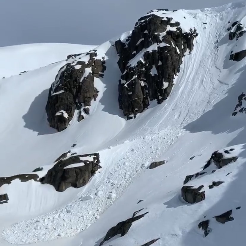
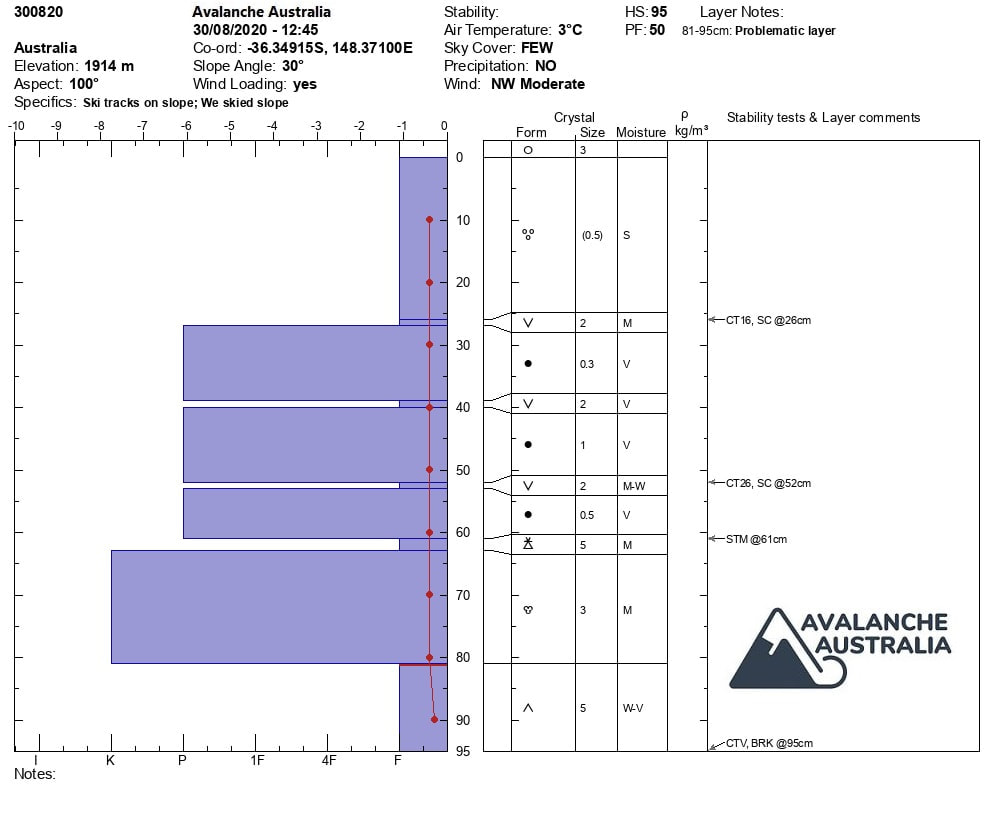
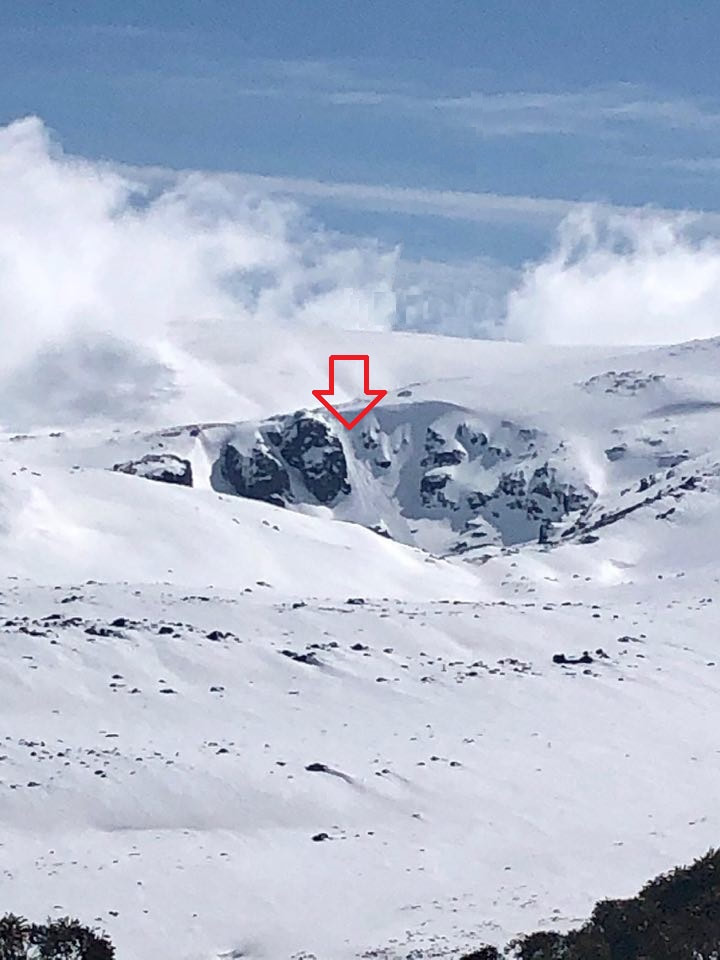
Cornice fall and avalanche at Blue lake Snowpack Summary The top 60 cm of the snowpack is very wet. Within the top 65 cm of the snowpack there are 3 layers of buried surface hoar (@26 cm, 39 cm and 52 cm) and a layer of graupel @ 61 cm. The layers at 26 and 52 had moderate to hard Compression Test results and we had a moderate Shovel Shear result @ 61 cm We had multiple Compression Test very easy results while cutting the back of the column at ground (95 cm) The snowpack below 1900 m early in the mornings will have a very thick melt/freeze crust until it becomes solar affected around midday. Primary concern is still the Wet slab failing on layers of buried surface hoar / graupel and the slab could vary in size from 26 cm to 61 cm. Secondary concern is cornice fall as the weather stays very warm over the next few days with freeze levels raising to 2900 m on Thursday. Tertiary concern is Deep Persistent Slab with the fist resistance layer at the bottom of the snowpack on the ground. This failed multiple times when cutting the snow columns. Extra caution should be used when skiing steep terrain on aspects North West through East to South for Wet Slab avalanches. Cornice failures are still a concern as this very warm weather continues, so stay off cornices and keep a safe distance while touring near them. The Persistent Deep Slab problem was evident from the avalanche to ground earlier in August and testing still shows that the bond of the snowpack to the ground is poor. Keep this in mind as the snowpack becomes heavier over the next few day with these warmer temperatures. |
24/08/2020
|
Avalanche Summary
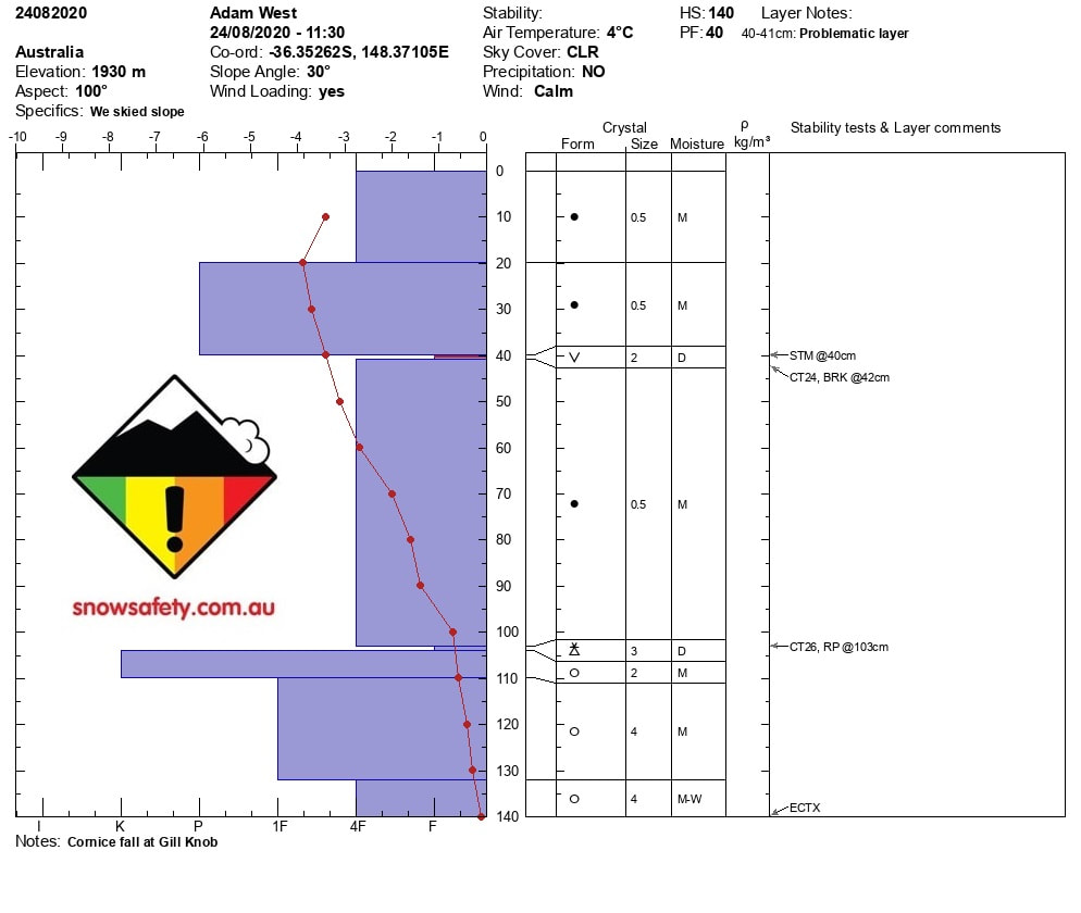
Cornice fall at Gills Knob Snowpack Summary The storm cycle has finished and the sun came out today! Very warm temperatures in the backcountry today, 4degC. The amount of new snow from the last storm was 100cm lee to the North West. Snow pack observations showed a density change in the snowpack between 20 and 40cm. At 41 cm there is a layer of buried surface hoar that when tested failed. At 103cm there is a layer of buried Graupel which also failed. Compression test results are as below CTH 24 BRK @ 42 cm on Buried Surface Hoar CTH 26 RP @103 cm on buried Graupel ECTX STM @ 40 cm The snow skied best on Saturday during the storm cycle and has become wetter as the storm finished late Sunday Stay aware of the risk on Wind slab on steeper slopes Lee to the North West on these solar aspects. As the snow gets heavier due to warming temperature will may see natural cornice falls and skier triggered slides. |
21/08/2020
Avalanche Summary
No recent activity
Snowpack Summary
New snow started early on the 18th in the alpine and has fallen on wet snow.
We will continue to monitor how this new snow will bond to the old surface snow.
Wind slab is expected to form on aspects lee to the North West with current wind speed of up to 45km/hr.
There is expected loading in the next week of +50cm of new snow so there will wind slab forming if the winds continue.
The temps are currently sitting high (-1.0 DegC @2050m) but we expect them to come down over the next 24hrs.
18/08/2020
Avalanche Summary
No recent activity
Snowpack Summary
New snow started early on the 18th in the alpine and has fallen on wet snow.
We will continue to monitor how this new snow will bond to the old surface snow.
Wind slab is expected to form on aspects lee to the North West with current wind speed of up to 45km/hr.
There is expected loading in the next week of +50cm of new snow so there will wind slab forming if the winds continue.
The temps are currently sitting high (-1.0 DegC @2050m) but we expect them to come down over the next 24hrs.
No recent activity
Snowpack Summary
New snow started early on the 18th in the alpine and has fallen on wet snow.
We will continue to monitor how this new snow will bond to the old surface snow.
Wind slab is expected to form on aspects lee to the North West with current wind speed of up to 45km/hr.
There is expected loading in the next week of +50cm of new snow so there will wind slab forming if the winds continue.
The temps are currently sitting high (-1.0 DegC @2050m) but we expect them to come down over the next 24hrs.
17/08/2020
valanche Summary
No recent activity
Snowpack Summary
With all the recent spring like conditions the snowpack in very wet and sticky.
Rain late last week and very warm day temps has meant that mornings and higher elevations were the pick of the terrain out in the BC.
There were no signs of any instabilities when testing the snowpack, but the concern is still there for wet slabs to release at ground level on steeper sunny aspects.
With the new storm cycle on its way (18th Aug) fingers crossed the predicted +50cm of new snow will be well welcomed on the thin spring like cover out there ATM
Be aware of the potential failure at ground level and stay off steep terrain in the warmer times of the day.
As this new storm cycle approaches we will keep you updated on how it bonds to wet surface.
11/08/2020
|
Avalanche Summary
No recent activity Snowpack Summary Since Sunday we have had very cold nights down to -6 on the main range. This has created a thick layer of melt / freeze on the surface and makes crampons a necessity while touring in the alpine. Rain Runnels are evident below alpine on most aspects. Snowpack was tested and showed no instabilities other than hard shovel shear results which failed at ground level. CT and ECT results showed no results. The colder temps have firmed up the very wet snowpack and we wait to see what nature delivers in the upcoming days. Light wind were a pleasant change today and it was a great day for touring except for the ice. Be aware of the potential failure at ground level and stay off steep terrain in the warmer times of the day |
|
10/08/2020
|
Avalanche Summary
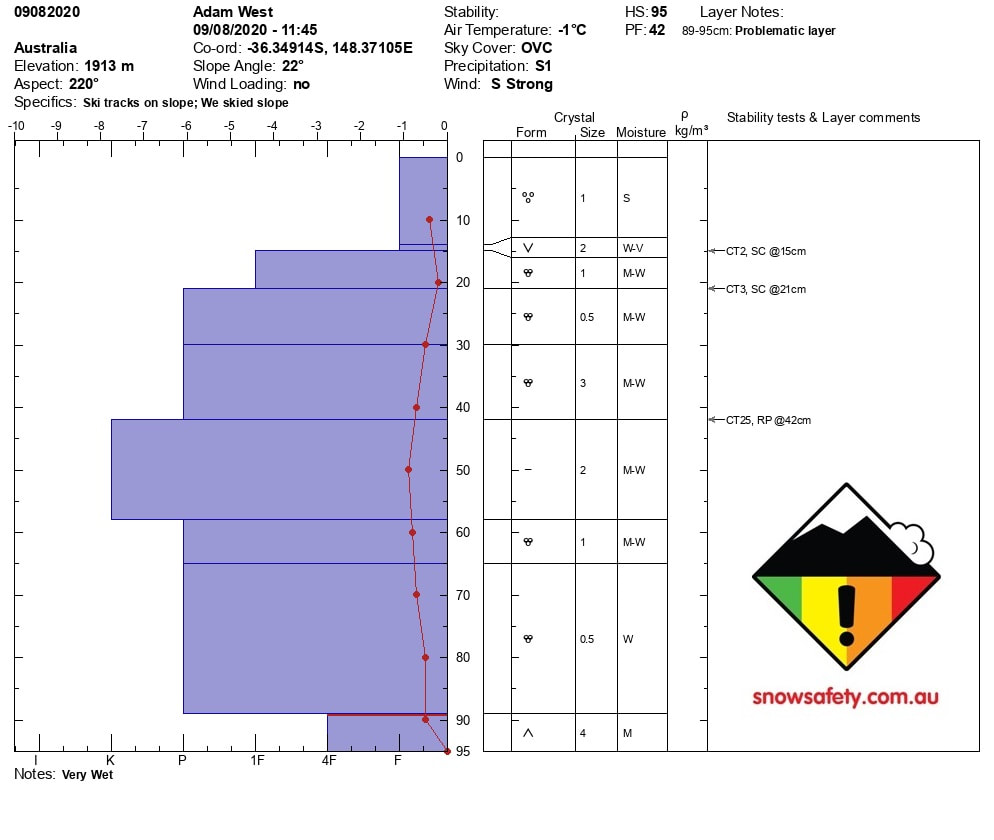
No recent activity Snowpack Summary With lower than forecasted temps for the NSW main range the expected snow fell as rain in most places. There was evidence of 40cm of very wet wind slab from Wednesday nights snowfall. This layer has started to bond to the melt freeze layer with resistive planar results on compression tests. Very low visibility was seen today while out doing observations. Sky cover was 8/8. Temperatures were sitting at -1 degC @ 1900m. Pit results showed a HS of 95 cm. Our Primary concern is a layer of depth hoar 6cm on the ground. This layer has been observed to have failed in the past 10 days and with the extra weight of the new wet snow will continue to be a problem on steep slopes. Our secondary concern is the recent 40cm of wet Wind Slab now Wet Slab sitting on the melt freeze crust. We had easy sudden collapse results at 15cm on buried surface hoar. We also had hard resistive planar results on the interface of the old wind slab on the melt freeze crust at 42cm Stay clear of steep terrain at all aspects as rain effected slopes will have Wet Slab issues. Stay safe while the visibility is poor in low altitude tree runs in the backcountry until these concerns are no longer apparent. |
07/08/2020
|
Avalanche Summary
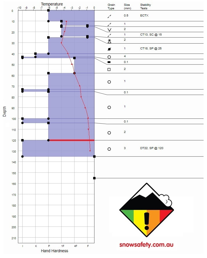
No recent activity Snowpack Summary More snow started falling from 11am on Friday the 07/08/2020 and should continue until Monday the 10/08/2020. Very low visibility was seen today while out doing observations. Sky cover was 8/8. Temperatures were cold with ambient sitting at -3 degC @ 1900m. Pit results showed a HS of 215 cm. Our Primary concern is a deep layer of persistent melt freeze at 120cm. This layer was tested with a deep tap test and got hard planar results on the 22nd tap. Our secondary concern is the recent 40cm of lee to the North West Wind Slab was sitting on the melt freeze crust from the warmer temperatures from earlier in the week. A layer of Graupel exists within the Wind Slab at 25cm and we had moderate Sudden planer results on this layer. We also had Moderate Sudden collapse results at 15cm on buried surface hoar also within the recent Wind Slab. We had no signs of propagation on the extended column tests. Moderate shove shear results on the graupel layer at 25cm. Stay clear of Lee to the North West aspect that are steep and stay safe while the visibility is poor in low altitude tree runs in the backcountry until these concerns are no longer apparent. |
03/08/2020
|
Avalanche Summary
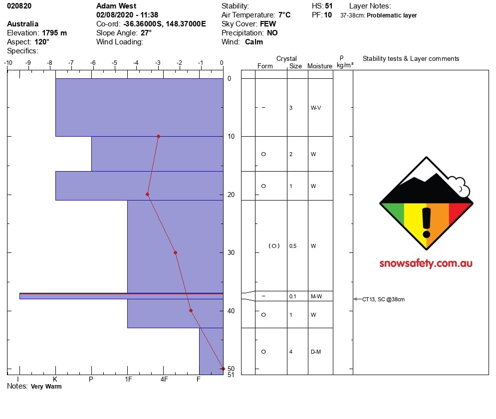
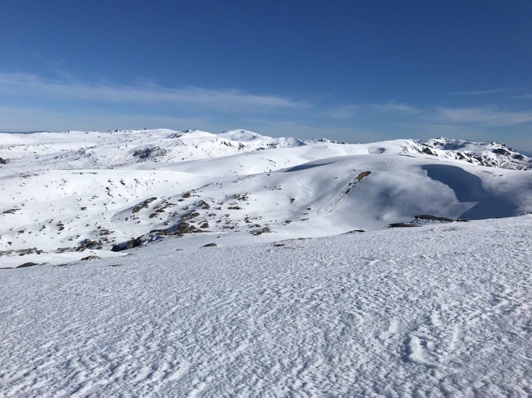
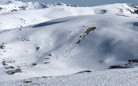
Size 1 wet slab release to ground at Mt Clark. Natural Avalanche, no skier involvement. Snowpack Summary There is a 10cm rain / sun crust on the surface thats only softening for a few hours around midday. Cold overnight temps are preserving this crust and making the backcountry very firm to ski on early in the day and in the late afternoons. Testing of the snow pack shows a total snow depth of 51cm. We had moderate compression test results with sudden collapsing at 35cm on the 1 finger layer of snow above the ice layer at 37cm. There is a 8cm layer of very low density snow on the ground which is fist resistance. This layer has been observered to have failed at Mt Clark during the week with a size one wet slab releasing. |
28/07/2020
|
Snowpack Summary
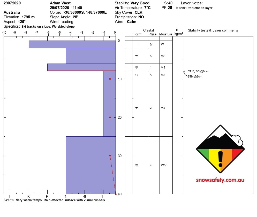
With rain starting on Sunday and continuing until Wednesday, the whole snowpack is now isotermal. The hard temperature gradient from last week has now gone weak and the snowpack is now cluster melt forms. We got moderated results on a rounding wet layer of buried surface hoar @8cm This layer was collapsing and sticking when tested and showed no signs any planar results The rain has fully saturated the low density layers that were persisting below 25cm in the snowpack. We will continue to check the stability of the snowpack throughout the week and report back with any changes. We will pray for some colder temps to "Firm " up the snowpack. Stay away from steep, thicker lee slopes as the risk of avalanche in these areas will have a greater consequence is it was to slide. |
24/07/2020
|
Snowpack Summary
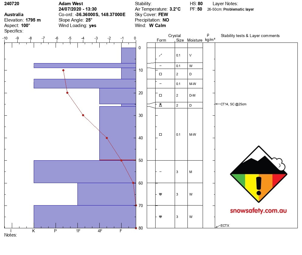
7cm of wind blown snow on lee to the NW was observed today. . This sits on one of many sun crusts buried in the snowpack currently. The snow event from the 13th of July is also very evident with 4 finger resistant snow from 18-51cm. Buried in this layer is a 1cm layer of graupel that we got sudden collapse results on CT test in the moderate range. the layer of concern for the snowpack is the low density snow from the 13th of july storm that is sitting on a sun crust. If this layers bond was to fail there would be a large 50cm slab. Stay clear of steep lee to the SW slopes until the the snow pack becomes more consolidated |
19/07/2020
|
Snowpack Summary
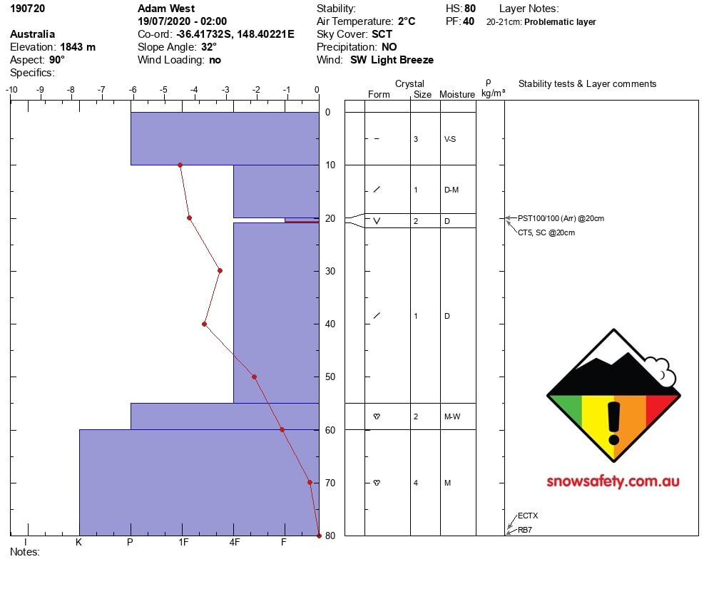
5cm of new snow on Sunday night has been loaded on slopes lee to the SW. The result is a 10cm sun crust in all ares that have not received this wind loaded snow. Our primary concern now is wind slab on these lee slopes No reported instabilities at this stage but we will continue to monitor the situation. |
12/07/2020
|
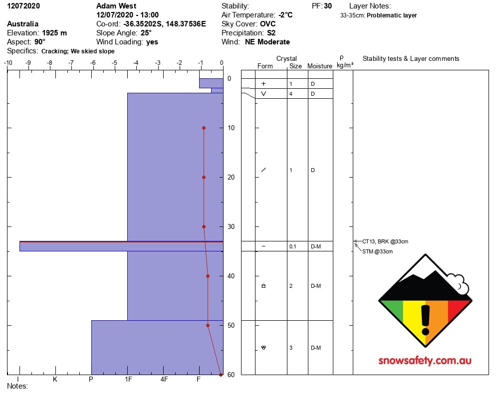
Snowpack Summary 60cm snowpack height. Snow reported down to 1000m in the NSW Main range. Caution on the roads today. With 25cm of new snow in the Alpine as of the 12.7.20 and the continued snowfall overnight we will need to keep the advisory at Moderate. Wind slab was forming on the 12 of July and will be increasing in size. All testing of the snowpack was showing that the new snow was bonding well to the melt freeze crust from last weeks stable warm condition. Moderate Shovel shear results @33cm Moderate Compression test with breaks @ 33cm No signs of instability were reported on the 12.07.20 Stay tuned for more info. |
05/07/2020
|
Snowpack Summary
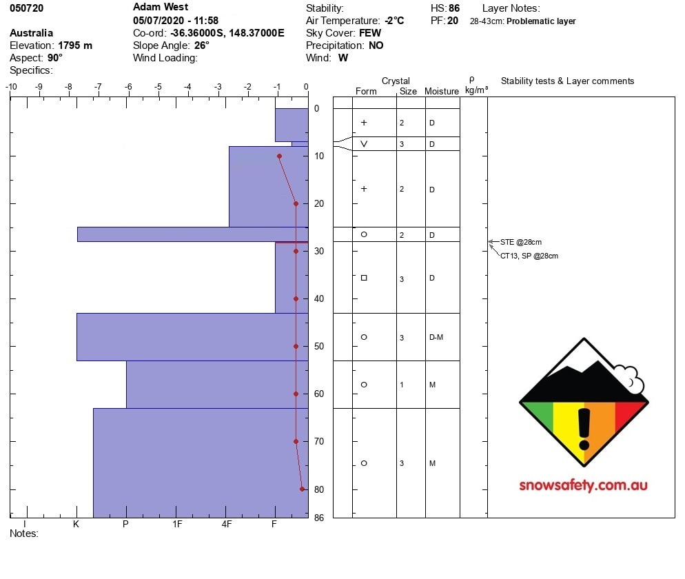
86 cm Snow height The snow has passed and looks to be returning on Friday the 10th of July. The storm cycle from the weekend has deposited 25cm of snow. This 25cm of new snow has a buried layer of Surface hoar @ 8cm from the surface. The new snow below the buried surface hoar has fallen on wet layer of melt-freeze and has bonded well after testing this interface. The top layer (25cm) of the snowpack is low density snow consisting of fist and 4 finger resistance layers. The layer of concern is Facets down at 28-46 cm as these are low density grains and have fist resistance. Easy Shovel Shear Results @ 28cm Compression Test result was Moderate (13) and was planar shear quality. |
02/07/2020
|
Snowpack Summary
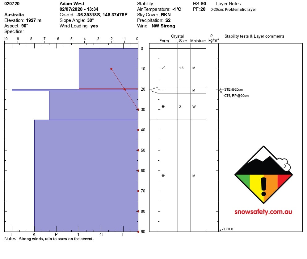
90 cm Snow height Blizzard conditions yesterday while out in the field Rain falling below 1500m turning to snow in the Alpine The rain has consolidated the low-density snow that was evident in the top 25cm of the snowpack before this this storm event. The new snow has fallen on wet layer of melt-freeze and has resistive bonding when testing this interface. The top layer of the snowpack is wind slab and we will continue to see grow over the day as this storm cycle continues. Easy Shovel Shear Results Compression Test result was easy (6) and there was a resistive planar result on the melt-freeze layer. No result from the Extended Column Test. |
28/06/2020
|
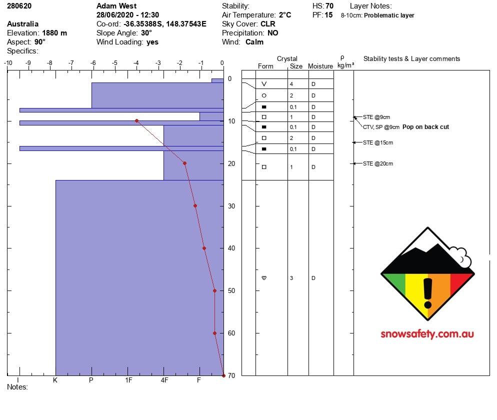
70 cm Snow height
The snow pack was covered with surface hoar from 1680 to 1880m Below the hoar is a sun crust with 6cm of melt forms at Pen resistance. There are 2 layers of faceted snow between sun crusts from 8-24cm with 4 finger resistance. We got CTV results while back cutting the column and easy shovel shear results on the facet layers Weather Forecast Rain starting on the 1st of july turning to snow on the 3rd and continuing to the 5th. We will publish more observations on the 1st of July. Hopefully the rain saturates the faceted layers and makes the top section of the snowpack more stable before the new snow arrives on the 3rd of July |
14/06/2020
|
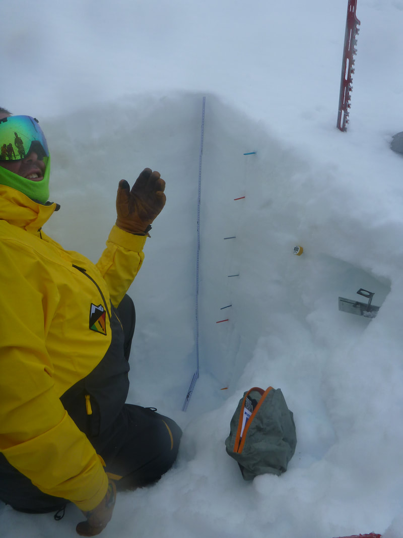
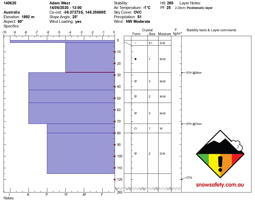
265 cm Snow height
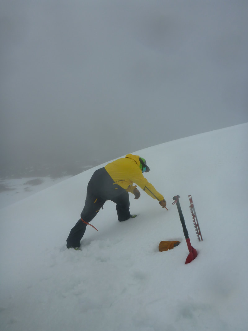
The snow pack has a sun crust on the surface, below this crust there is 1F resistance rounds to the depth of 28cm We got hard shovel shear results at 28cm and 72cm but no results from our compression test. Weather Forecast There was S1 precip during the day and this storm front will continue over the the next few days. |
02/05/2020
|
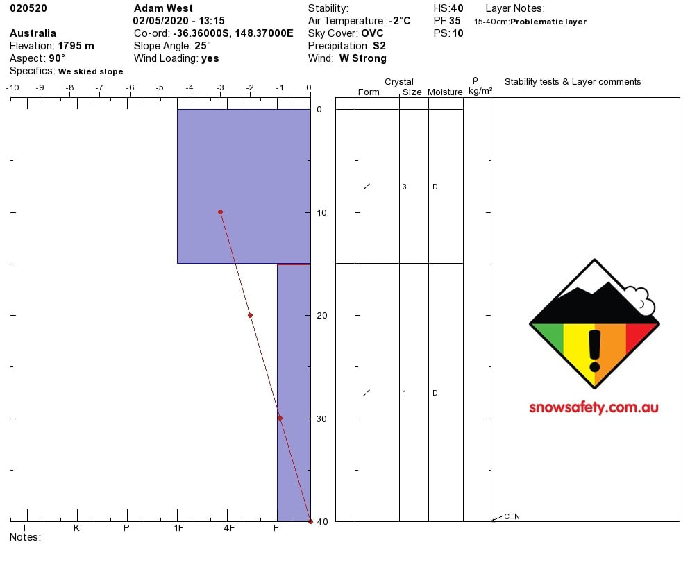
40 cm Snow height, There is a density change in the snowpack at 15cm. 0-15cm is 1F hardness, below 15cm is F hardness.
There is a reactive layer here, easy hand shear results, no CT results. Weather Forecast This storm cycle will continue over the weekend. More snow predicted till Monday the 4th of May. |

